- Log in
-
- Sydney Overseas Office
- London Overseas Office
- Toronto Overseas Office
- Los Angeles Overseas Office
- New York Overseas Office
- Ulaanbaatar Overseas Office
- Dubai Overseas Office
- New Delhi Overseas Office
- Manila Overseas Office
- Jakarta Overseas Office
- Hanoi Overseas Office
- Kuala Lumpur Overseas Office
- Singapore Overseas Office
- Bangkok Overseas Office
- Map
- Sydney Overseas Office
- London Overseas Office
- Toronto Overseas Office
- Los Angeles Overseas Office
- New York Overseas Office
- Ulaanbaatar Overseas Office
- Dubai Overseas Office
- New Delhi Overseas Office
- Manila Overseas Office
- Jakarta Overseas Office
- Hanoi Overseas Office
- Kuala Lumpur Overseas Office
- Singapore Overseas Office
- Bangkok Overseas Office
- HOME
- Where to Go
- Destinations
-
-
-
Dokdo (독도)
-
0
1
-
-
-
-
![]()
![]()
![]()
![]()
![]()
![]()
![]()
![]()
![]()
![]()
![]()
![]()
![]()
![]() 1 / 14
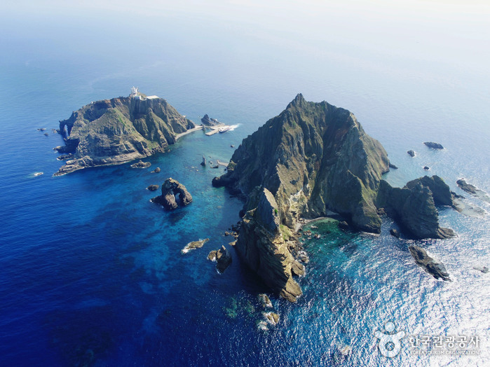
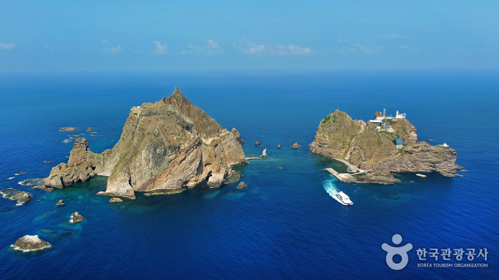
1 / 14Located 87.4 kilometers away from Ulleungdo Island, Dokdo is an island on the east coast of Korea. Dokdo comprises two major islands called Dongdo (East Island), located at a latitude of 37°14'N and a longitude of 131°52'E, and Seodo (West Island), located at a latitude of 37°14'N and a longitude of 131°51'E. Designated as a Natural Monument, Dokdo is a protected natural reserve that serves as a home to several rare and endangered bird species. Civilian access to Dokdo was prohibited in accordance with Article 33 of Cultural Heritage Protection Act until March 24, 2005, when adjustments were made with the law, granting the public access to Dongdo and Seodo under certain conditions. Since then, continued adjustments have been made, such as abolishing the number restriction of daily visitors, allowing more visitors to appreciate the beauty of Dokdo.
Dongdo, located on the southeastern coast, has a circumference of 2.8 kilometers and a surface area of 73,297 ㎡ with its highest peak reaching 98.6 meters. It also has a lighthouse and a wharf along with other marine and fishery facilities. As for Seodo, located on the northwestern coast, it has a circumference of 2.6 kilometers and a surface area of 88,740 ㎡ with the highest peak reaching 168.5 meters. Seodo houses living quarters of Dokdo's residents, where fishers seek shelter in case of an emergency. Several uniquely shaped rock formations are scattered surrounding the two major islands, such as Gajaebawi Rock, Chotdaebawi Rock, and Eolgulbawi Rock to name a few. The total surface area of all the rocks combined is 25,517 ㎡.What's nearby Here are some recommended destinations nearby! Attractions within 50 kilometers are arranged in the order of closest distance.Map Directions


Start a FREE Online Call
(No charges for calls on Wi-Fi /
Data charges may apply)

Open 1330 Helpline Chat(Download not required)